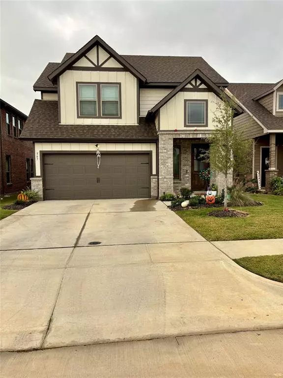
567 Ruthye Lane Pilot Point, TX 76258
4 Beds
3 Baths
2,122 SqFt
UPDATED:
11/10/2024 04:52 PM
Key Details
Property Type Single Family Home
Sub Type Single Family Residence
Listing Status Active
Purchase Type For Sale
Square Footage 2,122 sqft
Price per Sqft $150
Subdivision Ruthye Lane Add
MLS Listing ID 20769332
Style Craftsman
Bedrooms 4
Full Baths 3
HOA Fees $1,000/ann
HOA Y/N Mandatory
Year Built 2022
Annual Tax Amount $6,304
Lot Size 5,662 Sqft
Acres 0.13
Lot Dimensions 40 x 110
Property Description
Location
State TX
County Denton
Community Curbs, Perimeter Fencing, Sidewalks
Direction State 377 N Ray Roberts Pkwy, turn west onto E Burks St, north onto Dorothy Rd, Left onto Ruthye Ln, house on left.
Rooms
Dining Room 1
Interior
Interior Features Cable TV Available, Decorative Lighting, Double Vanity, Eat-in Kitchen, Granite Counters, Kitchen Island, Open Floorplan, Pantry, Walk-In Closet(s)
Heating Central, Electric
Cooling Ceiling Fan(s), Central Air, Electric
Flooring Carpet, Ceramic Tile
Appliance Dishwasher, Disposal, Electric Range, Electric Water Heater, Microwave
Heat Source Central, Electric
Laundry Electric Dryer Hookup, Utility Room, Full Size W/D Area, Washer Hookup
Exterior
Exterior Feature Covered Patio/Porch
Garage Spaces 2.0
Fence Back Yard, Fenced, Wood, Wrought Iron
Community Features Curbs, Perimeter Fencing, Sidewalks
Utilities Available Cable Available, City Sewer, City Water, Concrete, Curbs, Electricity Available, Individual Water Meter, Phone Available, Sidewalk, Underground Utilities
Roof Type Composition
Parking Type Garage, Garage Door Opener, Garage Double Door
Total Parking Spaces 2
Garage Yes
Building
Story Two
Foundation Slab
Level or Stories Two
Structure Type Brick,Vinyl Siding
Schools
Elementary Schools Pilot Point
Middle Schools Pilot Point
High Schools Pilot Point
School District Pilot Point Isd
Others
Restrictions Unknown Encumbrance(s)
Ownership Johnson
Acceptable Financing FHA, FHA Assumable, Fixed
Listing Terms FHA, FHA Assumable, Fixed
Special Listing Condition Agent Related to Owner, Utility Easement

GET MORE INFORMATION


